Leeds grew fast during the Industrial Revolution, and its subsurface tells that story. Behind the Victorian mills and modern tower blocks lies a mix of glacial till, alluvial silts, and made ground from centuries of mining and manufacturing. That legacy means you cannot trust a single soil profile across the city. Our team has logged hundreds of boreholes from Headingley to Hunslet, and we see the same pattern: variable drift thickness, old colliery spoil, and stiff boulder clay that demands careful classification. Before any foundation design or capacity of load analysis, we run full USCS and AASHTO classification to give your structural engineer numbers that actually match the ground. It is the first step, and we take it seriously.
Leeds glacial till and made ground demand site-specific classification — a generic soil map will not get you past NHBC or Building Control.
Scope of work in Leeds
Critical ground factors in Leeds
I worked on a site near Kirkstall where the developer assumed uniform stiff clay based on a single trial pit. The soil classification later showed a 2-metre lens of soft alluvial silt under the south corner — completely different material. That corner would have settled twice as much as the rest. We caught it because the USCS classification flagged a change from CL to ML within the same borehole. In Leeds, with its glacial channels and old river terraces, that kind of hidden variability is the norm, not the exception. Skipping classification means you design blind, and blind design costs money.
This service complements our laboratory testing work for a complete project analysis.
Our services
Our soil classification service is part of a wider geotechnical package. We tailor the work to your project stage — from feasibility through detailed design.
USCS Classification (BS EN ISO 14688-2)
Full visual-manual and laboratory classification: grain size distribution, Atterberg limits, group symbol and group name. Ideal for foundation design and earthworks specifications.
AASHTO Classification (M 145)
Group index calculation and soil rating for subgrade and pavement applications. Essential for road and infrastructure projects in the Leeds City Region.
Plasticity & Moisture Characterisation
Liquid limit, plastic limit, shrinkage limit, and natural moisture content. Critical for assessing shrink-swell risk in Leeds clay formations.
Gradation Analysis (Sieve + Hydrometer)
Complete particle size distribution from cobbles to clay fraction. Used to verify fill suitability, drainage potential, and compaction behaviour.
Watch how it works
FAQ
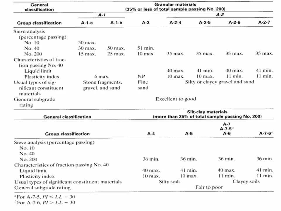
What is the difference between USCS and AASHTO soil classification?
USCS (Unified Soil Classification System) groups soils by grain size and plasticity — symbols like CH, SM, or GP are common. AASHTO rates soils for pavement subgrade performance using a group index from 0 to 20. Both are used in Leeds: USCS for foundations and earthworks, AASHTO for road design and highway schemes. We usually run both on the same sample.
How much does soil classification testing cost in Leeds?
A standard classification package — sieve analysis, Atterberg limits, and USCS/AASHTO classification — typically falls between £40 and £80 per sample. The exact figure depends on the number of samples and whether you need hydrometer or organic content testing. Contact us for a quote tailored to your project volume.
What soil types are most common in Leeds and how do they classify?
The predominant soil is glacial till — a stiff, heterogeneous mixture of clay, silt, sand, and gravel. Under USCS it usually classifies as CL or CH (lean to fat clay) with some GC (clayey gravel). Made ground and alluvial deposits along the Aire and Wharfe valleys classify as ML or SM. Each type behaves differently under load, so site-specific classification is essential.
How long does a soil classification test take?
Routine classification — sieving and Atterberg limits — is completed within 5 to 7 working days from sample receipt. Hydrometer analysis adds 2 to 3 days for the sedimentation phase. We prioritise Leeds projects with a fast turnaround when you are working to a tight programme.