Leeds sits in a rain shadow east of the Pennines, yet its annual precipitation still averages over 660 mm, and the underlying geology is dominated by Carboniferous Millstone Grit and Coal Measures with extensive glacial till deposits. These clay-rich tills are notorious for their low permeability, which means that without properly designed geotechnical road drainage, water gets trapped in the subgrade, leading to softening, loss of bearing capacity, and eventually pavement failure. In our experience, the key to durable roads in West Yorkshire is intercepting that water before it reaches the formation level. That is why we always start with a site-specific drainage strategy that accounts for the local groundwater regime and soil permeability, often complementing it with a permeability test in the laboratory to obtain accurate coefficients for design.
Glacial tills in Leeds have hydraulic conductivities below 10⁻⁹ m/s, making engineered road drainage essential to prevent subgrade softening and pavement failure.
Scope of work in Leeds
Critical ground factors in Leeds
One of the most common mistakes we see on road projects around Leeds is assuming that a simple ditch or a few cross-drains will suffice. The reality is that without a geotechnical drainage assessment, the contractor often ends up with water ponding under the pavement within the first winter, leading to differential settlement, cracking, and premature maintenance. In heavy clay areas like the outskirts of Leeds, this can turn a 20-year pavement into a 5-year problem. The risk is not just structural; standing water in the subgrade also causes frost heave during cold spells, which is a real hazard for road safety. We always insist on measuring in-situ permeability and installing drainage before the road base goes down.
This service complements our laboratory testing work for a complete project analysis.
Our services
Our team in Leeds offers a complete suite of services for road drainage projects, from initial site investigation to final design verification.
Subgrade Permeability Testing
In-situ falling head and constant head tests in boreholes and trial pits to obtain accurate hydraulic conductivity values for the Leeds tills.
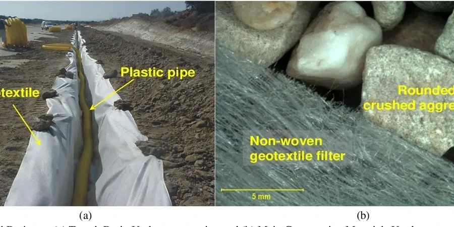
Drainage Design & Optimization
Sizing of trench drains, fin drains, and granular blankets based on site-specific flow rates, using Darcy's law and DMRB guidance.
Pore Pressure Monitoring
Installation of piezometers and standpipes to monitor groundwater levels and pore pressure changes during and after construction.
Watch how it works
FAQ
Why is geotechnical road drainage especially important in Leeds?
Leeds lies on glacial till with very low permeability. Without engineered drainage, water accumulates under the pavement, causing subgrade softening, differential settlement, and frost heave. The city's rainfall, though moderate, is frequent enough to keep the ground saturated for long periods.
What does a geotechnical drainage assessment for a road in Leeds involve?
We start with trial pits and in-situ permeability tests to understand the soil stratification and groundwater conditions. Then we design the drainage system (trench drains, fin drains, granular blankets) using site-specific flow rates and DMRB standards. We also check for potential slope stability issues in cut sections.
How much does a geotechnical drainage study cost in Leeds?
For a typical road project in Leeds, the cost ranges between £660 and £1,790, depending on the site area, number of trial pits, and complexity of the groundwater regime. This usually includes field testing, laboratory permeability tests, and a design report.